RTBMaps – a web-based GIS (Geographic Information Systems) tool to help planners visualize data and analyze options for using roots, tubers and bananas to improve food security, nutrition and income – has been selected for a Special Achievement in GIS (SAG) Award, presented today at the 2013 Esri International User Conference.
A collaboration of the International Center for Tropical Agriculture (CIAT) and the GIS teams at Bioversity International, the International Potato Center (CIP) and the International Institute of Tropical Agriculture (IITA), RTBMaps is harnessing the latest advances in GIS and cloud technology for the purpose of helping people in the world’s poorest regions.

Some of the most important decisions to be made in the first years of Roots, Tubers and Bananas (RTB) concern where the research program’s resources and activities can achieve the greatest impact. RTB crops are grown in regions with some of the world’s highest rates of poverty and malnutrition; but where could work on specific crops or issues go the farthest in improving food security, nutrition or income? What are the distributions of the principal pests, diseases and other constraints to production? What areas present the greatest opportunities for RTB?
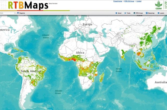
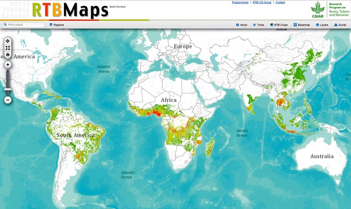
GIS specialists at the four research centers collaborating on RTB are helping the program’s decision makers to grapple with such issues by creating an online GIS tool to visualize production, constraints and social indicators associated with RTB crops. That online atlas is hosted by the CGIAR Consortium for Spatial Information (CSI). Together, these organizations have created a series of maps on ArcGIS Online, which uses cloud technology for GIS and allows users to build their own maps by combining layers.
“With this project, we want to move the power of maps out of the GIS lab and into the hands of the RTB science community – CGIAR scientists and our partners worldwide,” said Glenn Hyman, who is coordinating the project for CSI. He noted that the website is user friendly, accessible to all and free of charge. “Anybody can use these maps. You don’t need specific software. You don’t need any GIS training. All you need is a web browser.”
The four CGIAR participating centers – CIAT, CIP, Bioversity International and IITA – were selected to receive a Special Achievement in GIS (SAG) award at the 2013 Esri International User Conference. The award is given to user sites around the world to recognize outstanding work with GIS technology. RTBMaps was chosen from more than 100,000 others.
ESRI Conference 2013
Hyman said that RTBMaps is the most comprehensive and collaborative GIS web-mapping project to be undertaken within the CGIAR system to date. He noted that the cloud technology that it is based on has only become available in recent years.
RTBMaps is being launched with approximately 25 map layers, which are based on data for RTB crop distribution, indicators for poverty and food-security and some production constraints. However, the number of layers will grow as the GIS specialists at the research centers upload maps for additional pests and diseases, social indicators and other pertinent data. The RTB GIS team will also add applications for simple functions such as printing, or downloading maps for use in presentations. The team has also developed a priority setting application that allows users to weight the importance of different criteria – based on their own research, or consultations – and run analyses that result in unique maps.
Bernardo Creamer, an agricultural economist with the CGIAR Decision and Policy Analysis Program (DAPA), came up with the idea and worked with Hyman on the priority-setting tool. He explains that it could be used by anyone from breeders to social scientists to donors who are trying to decide where to focus their efforts or resources.
“I’m an economist, I don’t have a GIS background, but I can see the power of these maps,” Creamer said. “If all you look at are numbers, you may miss some important things. This tool helps you take criteria into consideration that you might otherwise ignore.”
According to Henry Juarez, who heads the GIS laboratory at CIP and has been working on GIS for more than a decade, the cloud technology and collaborative nature of RTBMaps are groundbreaking. He noted that the initiative has also resulted in unprecedented knowledge sharing among the GIS experts at the research centers involved.
“This is the first time I’ve been connected with the GIS specialists at the other research centers. I didn’t realize that there was so much information available,” he said.
Juarez was one of more than a dozen GIS experts and social scientists from the four RTB research centers who attended a workshop in November, 2012, at CIAT to learn ArcGIS Online, resolve technical issues, and set priorities for the mapping initiative.
“One of the great things about this project is that it has gotten the research centers involved in RTB to share their data,” Juarez said. He observed that in addition to creating a tool with great potential, the initiative has catalyzed knowledge sharing and collaboration, which are central to the RTB mission.